
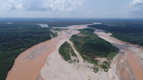
Impacts of alluvial mining in the Madre de Dios Basin: physical effects and mitigation planning
Funded by the NASEM and USAID. 100,000 USD. @UTEC: Dr. Mónica Moreno Brush (PI), Dr. Daniel Horna, @CINCIA: Dr. Luis Fernández (co-PI), Dr. Julio Aráujo, Dr. César Ascorra, Dr. Claudia Vega, @USDA: Dr. Eddy Langendoen
By combining state-of-the-art techniques in field measurement, remote sensing, and mathematical modeling of riverine processes, this proposal explores the interactions between flow, sediment transport, and channel change in rivers in association with the distribution of mercury along the food chain. The outcomes will provide useful insights for land managers and decision-makers on river morphodynamics and function, a crucial gap in the understanding of rivers, currently a critical national priority.
More information in the official webpage: https://sites.google.com/utec.edu.pe/rivermining/
Scientific Assessment of River Form and Flow: Baseline Information for Infrastructure Guidelines in the Peruvian Amazon
Funded by the Gordon and Betty Moore Foundation. 2'055,000 USD. @UTEC: Dr. Patrick Venail (PI)
The main objective is to understand the dynamics of water and sediment transport for the morphological description of Amazonian rivers and their interrelation with biodiversity and communities, in order to predict the impacts of river-related infrastructure intervention. The study entails the development of best practices to monitor Amazonian rivers and the multitemporal characterization of fluvial dynamics.
Portal 1: Amazon Basin
Portal 2: Dancing Rivers
Portal 3: Historias del Rio
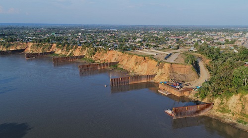
Study of the influence of breakwaters in The Pastora, Madre de Dios
Initiative.
The objective of the project is to evaluate the influence of the breakwaters (riparian defenses) implemented in the La Pastora area, which have been built as a contingency measure in 2015 due to the erosion of the river in that curve, thus avoiding the continuous proximity to the Interoceanic Highway Peru - Brazil. For this, the lateral migration of the Madre de Dios River is studied through a multitemporal analysis of satellite images. Also, explain the fluvial dynamics in the study area knowing the behavior of the velocities in specific sections of the river and the distribution of transported sediments in it, characterizing and quantifying them through pointed sampling (in channel and banks).
